The hidden history of a town's lost waterways

 Melksham & District Historical Association
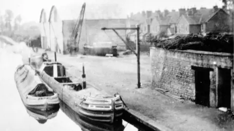
For more than a century, narrowboats pulled by horses and donkeys walking alongside Wiltshire's canals transported items like stone, timber, salt, beer, flour, beans and oil.
But if you take a look around Melksham now, there is little evidence of the town's watery history.
The canal between Semington and Lacock in Wiltshire stopped being used more than 100 years ago, largely due to intense competition from the railways. It was abandoned and largely filled in following its final closure in 1914.
Writer Peter Williams is now hoping to shed light on the lost history of the waterways in and around Melksham, which were once so important to the area.
The music teacher from Chippenham has spent 30 years gathering maps, letters, receipts, newspaper articles and dozens of archive images and sketches for his free book The Lost Waterway of Melksham.
He told BBC Radio Wiltshire he was "amazed" by the amount of information he managed to uncover.
"It's fascinating to think that narrowboats were travelling where homes and gardens stand today," Williams said.
He said locals described memories of skating to Chippenham when the canal froze over in winter and coal barges being cleaned out for groups to enjoy annual outings to the town in the summer.
 Justin Guy
The route of the canal stretched from the Semington junction, where there was a toll collector's house, and past Berryfields. It then carried on to Melksham Wharf, where there was once a wharf keeper's cottage, cranes and warehouses - now home to a development of flats called Wharf Court.
The former rope factory at modern-day Rope Walk is also featured in the book, as well as a list of names of local boatmen, boatbuilders and lockkeepers.
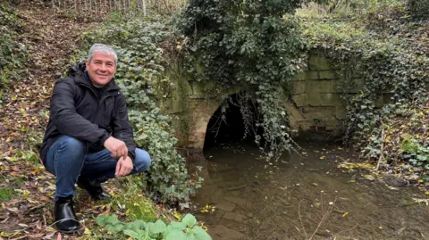
So are there any echoes of the canals' presence left in Melksham? Williams said there were a number of clues people could still find.
The first is a hump in Spa Road where the Wharf Court residential home is - marking where a bridge once was.
He also pointed to the bridge parapet at the junction of Lowbourne Road and Forest Road.
'M4 of its time'
He added some small parts of the towpath were now public rights of way between houses.
"There was also a big embankment over Clackers Brook, which is just off Ruskin Avenue.
"It would have been huge in 1795 when it was constructed. It was like the M4 of its time.
"The people of Melksham must have been quite amazed by this huge engineering feature which came through the town," Williams said.
He was inspired to start the project after volunteering with the Melksham, Chippenham and Calne branch of the Wilts & Berks Canal Trust.
The charity is hoping to receive planning permission for a "Melksham Link", which would uncover and reconnect the town's waterways with the nearby Kennet & Avon Canal.
The plans are currently being discussed by Wiltshire Council and the Environment Agency.
Mike Gibbin, CEO of Wilts & Berks Canal Trust, said: "Peter has produced an excellent book, and we are delighted he has kindly offered to share it with everyone free of charge.
"We hope it encourages people to learn about the amazing story of this wonderful waterway and our ambitious plans to bring it back to life."
Follow BBC Wiltshire on Facebook, X and Instagram. Send your story ideas to us on email or via WhatsApp on 0800 313 4630.
