Venezuela earthquakes in maps and graphics - where they hit and how severe they could be

Ten-storey hotel collapses in La Guaira

Two strong earthquakes that struck Venezuela within seconds of one another have caused untold damage to homes and buildings in several parts of the country, the deaths of at least 164 people and left hundreds more injured.

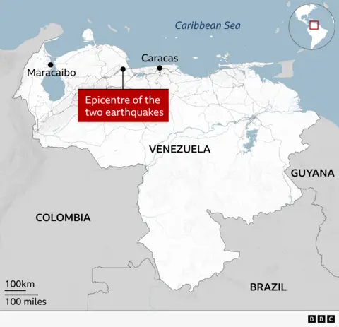
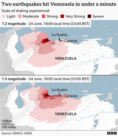
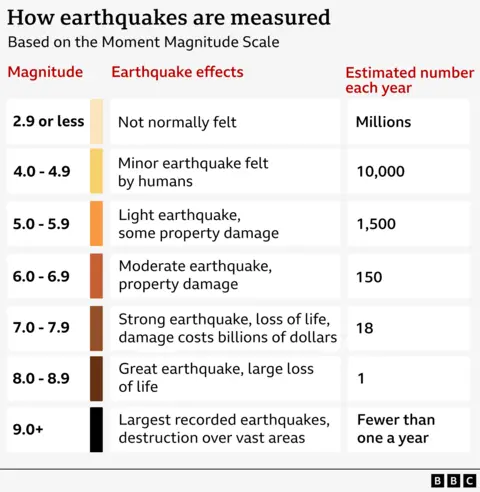
The first earthquake - with a magnitude of 7.2 - struck at 18:04 local time (22:04 GMT) 23km south-east of Yumare, a town to the west of the capital, Caracas, according to the US Geological Society (USGS).

The second 7.5-magnitude quake hit in a similar location just 38 seconds later.

News imageMap of northern South America focusing on Venezuela, showing the location of two earthquake epicentres inland between Maracaibo in the west) and Caracas on the central north coast. The Caribbean Sea is labelled to the north, with neighbouring countries Colombia, Guyana, and Brazil also marked. An inset map in the top right shows the region’s position within the Americas.

The shaking, particularly from the second quake, caused buildings in Caracas and the nearby seaside city of La Guaira to be damaged or completely collapse.

Venezuela's interior minister said the states of Trujillo, Yaracuy, Carabobo, Aragua and Miranda had also been affected.

News imageTwo maps showing powerful earthquakes striking northern Venezuela less than a minute apart on 24 June. The first, magnitude 7.2 at 18:04 local time, produced strong to severe shaking concentrated inland near the coast, while the second, slightly larger magnitude 7.5 at 18:05, spread more intense shaking across a wider area particularly along the northern coast. The maps use a colour scale from light to severe to illustrate shaking intensity, highlighting heavily affected zones around La Guaira and Caracas, with broader regions experiencing moderate to strong tremors. The source is GDACS and the USGS

The country's main international airport, on the outskirts of Caracas, has been closed due to serious damage, the Latin American nation's interim President Delcy Rodríguez said.

Video from inside the terminal shows dust and debris falling from the ceiling.

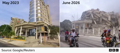
The BBC has verified footage of a 10-storey hotel in La Guaira that has been reduced to rubble.

Only the entrance to Eduard's Hotel can be seen standing, with the debris of the rest of the structure piled on top of it.

News imageImages of Eduard's Hotel in La Guiara in May 2023, showing the hotel standing, and June 2026 following two earthquakes, in which the building has been reduced to a pile of rubble

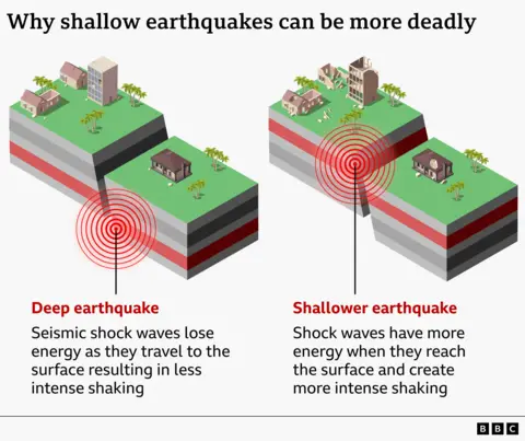
It's not just the magnitude of the earthquake that has a bearing on its destructive power, but how close to the surface it occurs, as well as the size of the nearby population and the quality of the buildings in the area.

The first quake was 20.3km below the surface and the second at a depth of just 10km, according to the USGS, increasing the likelihood of damage on the surface.

The agency estimated a 44% chance of more than 10,000 deaths.

News imageGraphic titled “Why shallow earthquakes can be more deadly” comparing deep and shallow earthquakes. On the left, a deep earthquake is shown beneath the surface, with red shockwave circles spreading upward and losing energy before reaching a block of land with a house and trees, resulting in less intense shaking. On the right, a shallower earthquake occurs closer to the surface, with shockwaves reaching the ground with more energy beneath a similar block, causing stronger shaking.
News imageA chart explaining how earthquakes are measured based on the Moment Magnitude Scale. It has three columns: Magnitude, Earthquake effects, and Estimated number each year. The rows are: Magnitude 2.9 or less – Effects not normally felt – There are millions per year; Magnitude 4 to 4.9 – Minor earthquake felt by humans – 10,000 per year; Magnitude 5 to 5.9 – Light earthquake, some property damage – 1,500 per year; Magnitude 6 to 6.9 – Moderate earthquake, property damage – 150 per year; Magnitude 7 – 7.9 – Strong earthquake, loss of life, damage costs billions – 18 per year; Magnitude 8 – 8.9 – Great earthquake, large loss of life – 1 per year; Magnitude 9+ – Largest recorded earthquakes, destruction over vast areas – Fewer than one per year

Venezuela lies along the boundary between the Caribbean and South American tectonic plates, which are moving past one another.

The USGS says the sudden release of friction between these two plates is likely to have triggered the earthquakes.