Oxford St pedestrianisation: What you need to know

 Oxford Street Development Corporation
Cars, buses, taxis and bicycles are set to disappear from much of Oxford Street later this month, as part of a scheme to pedestrianise almost a kilometre of the road.
The major overhaul of the popular shopping destination will begin this autumn, with the first phase of the scheme expected to be finished by spring 2027.
Here's everything we know about the plans so far.
What is happening to Oxford Street?
 Oxford Street Development Corporation
Oxford Street will be pedestrianised between Orchard Street and Great Portland Street from 26 October.
Traffic will still be able to flow north and south along Regent Street at the Oxford Circus junction.
Pedestrians will be able to cross at the junction and traffic signals will be rephased for the changes.

Traffic will also be able to cross the pedestrianised zone on these four other routes:
- Duke Street (northbound)
- Davies Street/Stratford Place (both directions for local access)
- Vere Street/New Bond Street (southbound only)
- Holles Street (northbound only)
The Oxford Street Development Corporation said it estimated that temporary improvements to the area would be completed by spring 2027.
Access to or from Oxford Street via James Street, Binney Street and Gilbert Street will end at 22:00 BSTon 19 October in preparation for the final road layout, Transport for London (TfL) said.
 AVR London/Mayor of London
TfL said buses and other traffic would be diverted away from Oxford Street between Portman Street and Winsley Street from 20:00 GMT on 25 October.
Binney Street will become two-way between Oxford Street and Weighhouse Street, and will permanently close access to Oxford Street.
And the traffic-free area will be reduced to between Orchard Street and Great Portland Street on the morning of Monday 26 October.
The development corporation said the first stage of pedestrianisation was a "test and review" phase that would inform final designs for the area.
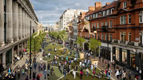
What will Oxford Street look like?
To begin with, the road layout will remain unchanged, but TfL said it was looking to raise the road height to meet the pavement level along the pedestrianised area.
It said the first two sections between Orchard Street and Duke Street, and between Old Cavendish Street and Holles Street, were planned to be completed in spring 2027, and more works would follow later.
All pedestrian crossings along Oxford Street will have tactile paving and accessible crossing points with dropped kerbs, TfL added.
How will people get around?
A number of bus routes will be diverted on to different roads as part of the first phase of pedestrianisation between Orchard Street and Great Portland Street.
These changes will begin at 01:00 BST on 24 October.
Bus routes 98, 139, 390 , N98 and N207 will be diverted nearby and will use new bus stops on Wigmore Street, Henrietta Place and Cavendish Place.
Bus routes 7, N7, 94, N113, N137 will terminate in the Marble Arch area.
There will be minor changes to routes 2, 13, 73, 74, 113, 159, 189, 274, N2, N8, N15, N25, N73, N74, N109, N136, including changes to bus stops.
From 20:00 GMT on 25 October until 06:00 the following morning, some bus routes will be diverted or finish earlier than usual.
 TfL
TfL said alternative bus stops would be about 200m from the traffic-free area, and taxi ranks would be about 100m away.
TfL added that it would place staff near bus stops and on Oxford Street to help people find their way in the early stages of the street changes, and signs would be installed with route-finding information.
How will businesses be affected?
Servicing and delivery vehicles will be permitted in the pedestrianised part of Oxford Street between midnight and 07:00 every day in specific locations.
Businesses can also continue to be serviced by sideroads.
Waste collection will continue to be provided by Westminster City Council, and the Oxford Street Development Corporation will fund liveried cargo e-bikes for litter collection and street cleaning during pedestrianised hours.
Most of the work on pedestrianisation changes will be done overnight, but safety barriers and some other works will be installed during the day, TfL said.
Where will the traffic go?
An increase in traffic is expected on Wigmore Street, Cavendish Place, Henrietta Place, Marylebone Lane and Welbeck Street as buses will use these streets and they provide an east-to-west alternative to Oxford Street, TfL said.
Margaret Street, Upper Brook Street, Marylebone Lane, Dunraven Street and Stratford Place are expected to see an increase in traffic noise between 3.2dB and 7.8dB because of the changes.
The largest reductions in traffic noise are expected on Oxford Street, Bryanston Street and James Street.
TfL said it expected to see an improvement in air quality in several locations in the Oxford Street west area, with other locations showing "no material effect".
Will it be safe?
The Oxford Street Development Corporation said it was working with the Metropolitan Police, British Transport Police, TfL, the council, the New West End Company (NWEC), businesses and community groups to prioritise public safety and tackle issues such as antisocial behaviour and theft on the street.
The corporation said it was looking at increasing security support from NWEC in the street once it is traffic-free.
It said that in emergencies, police, ambulances and the fire service would be able to access the pedestrianised areas along "multiple access points".
The corporation said it had worked with the emergency services to understand their access needs and would continue to do so as the changes began.
TfL said pedestrians would be kept safe with barriers in areas where traffic could cross Oxford Street travelling north or south, and on previous entry and exit points.
It said it was also looking to improve street lighting and CCTV coverage along the pedestrianised area.
What about trees and greenery?
 Oxford Street Development Corporation
By the end of spring 2027, more than 50 new trees and more than 100 new seats, including chairs and benches, will be installed along the pedestrianised area, the corporation said.
Two areas of temporary raised road surface will also be added to create public squares that may be used as event spaces.
A seasonal temporary water feature is also being considered, the corporation said.
TfL will be responsible for the ongoing upkeep of the area, instead of Westminster City Council.
How much will it cost?
The project is expected to cost £150m, which includes the cost of highway changes.
The corporation said it was looking to generate funds from a range of sources including advertising, sponsorship and philanthropic contributions and borrowing.
The corporation said that possible future phases were being considered and costed.
Listen to the best of BBC Radio London on Sounds and follow BBC London on Facebook, X and Instagram. Send your story ideas to hello.bbclondon@bbc.co.uk
