Archaeologists reveal wooden secret beneath ancient stone island

 PA Media
An ancient artificial island in a loch on the Isle of Lewis was built entirely on a wooden platform, archaeologists have discovered.
From above, the Neolithic island - or crannog - in Loch Bhorgastail appears to be made of stone, though it was known that there was some timber underneath it.
However, researchers from the University of Southampton carried out an excavation and have revealed that wood was used to support the whole structure.
The group dated their findings between 3500 and 3300 BC - around the early Bronze Age - and said the technique would have been used at other nearby sites throughout the Outer Hebrides.
University of Southampton archaeologist, Dr Stephanie Blankshein, said: "When we actually started excavating is when we realised that it was actually this coherent, quite large timber structure that was under what you would see as the stone island today.
"While we still don't know exactly why these islands were built, the resources and labour required to construct them suggests not only complex communities capable of such feats, but also the great significance of these sites."
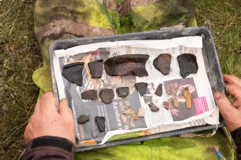
As well as the layered wood and brushwood construction under the stone, archaeologists found hundreds of pieces of Neolithic pottery in the surrounding water.
 PA Media
Crannogs are small artificial islands that are typically thousands of years old, and hundreds of them exist in Scotland's lochs.
The site in Loch Bhorgastail was first discovered in 2009.
Through fieldwork carried out since 2021, the archaeologists have revealed the different stages of development of the crannog.
They discovered that it was first established more than 5,000 years ago and started out as a circular wooden platform, around 23m (75ft) across, topped with brushwood.
Around 2,000 years later in the Middle Bronze Age, another layer of brushwood and stone were added, with more activity around 1,000 years after that during the Iron Age.
A stone causeway, now underwater, leads from the loch shore to the island.
 PA Media
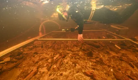
As part of the fieldwork, the researchers created images of how the island looks above and below the water line using the science of photogrammetry.
This is when photographs of the subject are taken from multiple different angles and then "stitched" together by specialist software to create a high resolution digital model.
Carrying out photogrammetry in shallow water, such as that around the crannog, poses difficulties so the archaeologists created a new technique for doing so during their fieldwork.
They used two small waterproof cameras – with low-light performance and a wide-field of view.
These were locked at a set distance apart on a frame, providing precise overlapping of imagery, to help compensate for any missing or disrupted data.
The cameras were manoeuvred through the water by a diver with positioning controlled to centimetre accuracy, which is said to match that achieved by an aerial drone.
Their technique is described in a newly published article in the journal Advances in Archaeological Practice.
The images were created alongside experts from the University of Reading.
