This film explores the different types of erosion and their dramatic effect on landscapes around the world.
Video
Erosion is when land is worn away by another material. It's a natural process that's been going on for millions of years and it continues to shape our planet's landscape today.
Water is the Earth's main natural eroding force. The same seemingly harmless liquid we drink, has the power to sculpt the land around us.
There are four main types of water erosion:
Hydraulic action, when the power of the water causes the material to break apart;
Abrasion, when stones, pebbles and other sediment grind along the material in a sandpapering effect;
Attrition when rocks that are carried in the water, knock against each other and break apart to become smaller and more rounded;
And solution, when the water dissolves certain types of rocks, for example, limestone.
The speed with which erosion wears away the land depends on the force of the water and the durability of the material that's being worn away.
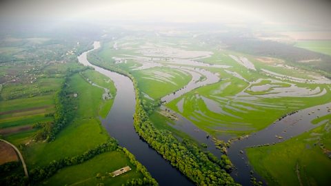
In rivers, strong, fast currents erode the riverbank and riverbed as the water moves along. River erosion like this often creates a V-shaped valley and features like meanders and oxbow lakes. Even a gentle, slow flow will have an impact over time.
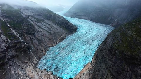
Frozen water does the same thing, but at a much slower pace. This is called glacial erosion.
As glaciers move down mountains and hills, they wear away the land, a bit like sandpaper.
Glaciers leave behind distinctive U-shaped valleys.
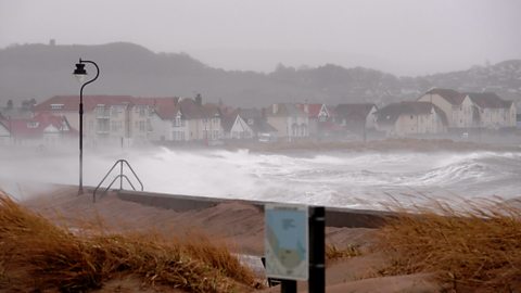
The sea is another powerful eroding force, crashing into the coastline and wearing it away over time.
For example, the hydraulic action of the sea can create a crack in a cliff wall, which will eventually turn into a cave, this will eventually become an arch, then a stack and finally, a stump, which simply erodes away to nothing.
Coastal erosion creates stunning coastlines, but it can also lead to changes to the shoreline and to the loss of homes.
In 2013, three houses in the seaside village of Hemsby in Norfolk literally fell into the sea during storms that caused dramatic erosion to a cliff side, already severely eroded.
By 2018, five more houses were so close to the edge, that they had to be demolished before they fell into the sea below.
Many experts believe that climate change and melting ice is adding to a rise in sea levels as well as increased storms.
These two factors are accelerating the rate of coastal erosion in the United Kingdom and across the globe.
Video summary
This short film, first published in 2020, is for teachers and review is recommended before use in class.
Download/print a transcript of the video.
A short film for secondary schools explaining the various types of erosion and illustrating the dramatic effect the process has had on landscapes across the world.
It charts the impact erosion has on landscapes and how different types of erosion cause the land to wear away in different ways.
This short film helps meet the requirements of the National Curriculum in physical geography at KS3 with regard to:
- geological timescales and plate tectonics
- rocks, weathering and soils
- weather and climate, including the change in climate from the Ice Age to the present
- glaciation, hydrology and coasts.
Teacher notes
Download/print the Teacher Notes for this episode (pdf).
Before watching the video
Ask students what they think is meant by the word erosion. The etymology of the word could be looked at to see whether students can create a definition based in the etymology.
Show students a range of landforms and ask students how they think they are formed.
Introduce key terms such as:
Erosion: The process where natural forces like wind, water, or ice wear away and transport soil, rock, and other materials from one location to another.
Meander: A bend in the river.
Glacier: A slow-moving river of ice.
During the video
You may wish to stop at relevant points during this short film to pose questions and check understanding or wait until the end. Useful questions might include:
- What are the four main types of water erosion?
- Describe abrasion.
- Describe attrition.
- Describe solution.
- Describe hydraulic action.
- What river landforms are created by erosion?
- Name a landform created by glacial erosion?
- What coastal landforms are created by erosion?
- What problems can erosion cause?
- What is increasing erosion in the UK?
After watching
Ask students to draw diagrams of the different type of erosion in the context in which they happen. They should accompany this with a description of each and then use this information to help them to answer an exam style question such as “Describe how a river erodes its channel”.
Look at a range of different landforms that have been created by erosion. Ask students to predict how they were formed based on their knowledge of erosion. Students could then draw how each landform has been created as a storyboard or a flow chart, using subject specific vocabulary to describe each stage of its formation.
Where next?
Choose a location which is experiencing dramatic coastal erosion such as Happisburgh in Norfolk. What are the impacts of coastal erosion?
Categorise the impacts into social, economic and environmental.
What responses have there been to the erosion, for example have coastal defences been built or have local people tried to defend their homes.
Students and teachers over the age of 16 can create a free Financial Times account. For a Financial Times article about costal erosion, click here, and for a video about soil and erosion from 2024, click here.
Curriculum notes
This short film is relevant for teaching geography at KS3 in England, Wales and Northern Ireland and 3rd and 4th Level in Scotland.
This short film helps meet the requirement of the Key Stage 3 national curriculum in geography requirement to develop and understanding of:
- physical geography relating to: geological timescales and plate tectonics; rocks, weathering and soils; weather and climate, including the change in climate from the Ice Age to the present; and glaciation, hydrology and coasts.
More videos from this series
Primary and secondary industries. video
A short film for secondary schools explaining primary and secondary industries.
Tertiary and quaternary industries. video
A short film for secondary schools explaining tertiary and quaternary industries, what they are and how they fit into global economy.

Plate tectonics. video
A short animated film for secondary schools detailing tectonic plates, their movement and boundaries, and what this means for Earth.
Responses to flooding. video
A short film for secondary schools explaining the common responses to flooding and the methods employed to prevent and reduce flooding. Footage shows examples of hard and soft engineering techniques.
Glaciation. video
A short film for secondary schools explaining glaciation: what it is, how it shapes the land and the effects of climate change on the world’s glaciers.
Rapid urbanisation. video
Investigates how rapid urbanisation impacts on both urban and rural areas and the challenges this presents.
Coastal flooding. video
Illustrated with case studies, this short film for secondary schools explains the causes and results of coastal flooding, focussing primarily on instances in the UK.
River flooding. video
A short film for secondary schools offering explanation of the causes and effects of river flooding. Footage shows examples of case studies of river flooding in the UK and across the world.
Climate. video
A short animated film for secondary schools describing the factors that determine the climate of a country and the main climate zones of the world.