A child-led introduction to the North Frisian island of Sylt, Germany, suitable to support study of a European location at KS2.
Helen: Hello, my name is Helen. I am 11 years old. I live in Rantum on Sylt.
Helen - TRANSLATED: And down there, is where I live. Sylt is the biggest German North Sea island, with an area of 99 square kilometres. There are 11 villages on Sylt, and one town called Westerland. Rantum, where I live, is one of the narrowest parts of the island.
My pets are chickens. My guitar teacher is called Oliver, and he also teaches my brother piano. I started when I was six years old. I couldn't even write then, and now I have been playing for four years.
I was born here on Sylt, and I have lived here my whole life. I live here with my brother and my parents.
Sylt has a population of 21,500. It is just 38.5 kilometres long from north to south. And east to west, it is between 350 and 12,600 metres wide. A third of the island is covered with dunes. The rest is covered with heathland and marsh.
In Sylt, the wind blows mainly from the West. There are lots of thatched houses on Sylt. In the past, reeds grown on the island were used to make their roofs.
In winter, far fewer people live on Sylt. Lots of people only come in the summer to spend time in their summer houses. Over 800,000 people a year come here on holiday.
Since the 1st June 1927, Sylt has been connected to the German mainland via the Hindenburg dam. To stop Sylt shrinking, sometimes a ship anchors off the coast, sucks up the sand from the sea bed and squirts it back onto the beach.
The Wadden Sea is a nature reserve on the more protected east coast of Sylt. I am here with my friends, because we are really interested in the Wadden Sea, and we are young Wadden Sea guides. Kirsten says you can only protect and conserve what you know about, which means, that if we really get to know the Wadden Sea, then we'll know how best to take care of it.
Kirsten – TRANSLATED: This is sponge. Like Spongebob. It is a native sponge of the North Sea. And when the mussel boats dredge the mussels from the sea, they destroy the sponges and everything else on the seabed.
Helen - TRANSLATED: Kirsten has shown us all the different plants and animals on the Wadden Sea. Up to two million tiny plants and organisms can live in one square metre of the Wadden seabed.
Svea, Samira, and I have learnt a lot about the ebb and flow of the tides. We know that the tide goes in and out, or ebbs and flows, because the earth is spinning. And when you spin around, you are forced away from each other. The same thing happens to the water on the earth when the earth spins. There are two high tides and two low tides every 24 hours.
Because of the wind, the weather changes very quickly and it often doesn't stay bad for long. Sylt is an extreme place to live in and we love it!
Video summary
Download/print a transcript of the video.
Sylt is an island very close to Germany and Denmark.
Connected by the Hindenburg causeway to the mainland, this 30km long island is only a few hundred metres across at its thinnest point. It is covered in dunes and heathland, and battered by the strong westerly winds from the North Sea.
Its west coast is constantly subjected to coastal erosion; but sheltered on the east, where the Wadden Sea lies, is a world heritage site.
11-year-old Helen explains what life is like on the island and how the impact of tourism and migration has changed Sylt's geography.
Helen and her friends show us the Wadden Sea and the important conservation work being undertaken there.
Teacher Notes
Download/print the Teacher Notes for this episode (pdf).
Teacher Notes prepared in partnership with the Geographical Association.
Central idea
- There are multiple perspectives around how a place should function.
Think, work and apply like a geographer
- Compare
- Sustainability
- Perspective & viewpoint
Questions to explore
- Where are Sylt and Germany?
- Which countries and seas border Germany?
- What is life like on a small island?
- How does tourism impact a place?
- Why should areas be protected and conserved?
- What are the impacts of seasonal migration?
Key learning outcomes
- To know how to use a map to locate place.
- To know how to make a map and include its key features of scale, symbols, key and compass rose.
- To know that different perspectives about place help shape what it is like.
- To know that (seasonal) tourism has both positive and negative impacts on a place
Geographical vocabulary
- Dam
- Causeway
- Climate
- Population
- Tourism
- Island
- Seasons
- Dunes
- Heathland
- Marsh
Suggested learning opportunities
Is tourism a good or bad thing?
- In small groups pupils compare the pros and cons of tourism and especially seasonal tourism on a location such as Sylt.
- Pupils create a tourist leaflet to encourage people to minimise their impact on the island when they visit.
- Pupils debate whether a further increase in tourist numbers are a good thing- roles such as local permanent resident, business owner, tourist, etc.
Design an island
- In small groups pupils draw a map, with symbols and key for an island that that focuses on one of the four categories, the needs of: residents, tourists, sustainability or conservation.
- The four groups then work together to create a ‘master map’ that balances the needs of all four considerations. Discuss the challenges of meeting the needs of everyone.
Ideas for going further and links
- Investigate other human made issues and problems that seas and oceans face, how these might be solved and what actions pupils might take to support these.
KS2 Geography: A location in Europe - Hamburg, Germany
KS2 Geography: Tourism
KS2 Geography: Shore, coast and ocean
This film is relevant for teaching Key Stage 2 and Key Stage 3 in England and Northern Ireland, Progression Step 3 in Wales and 3rd Level (Scotland). The National Curriculum for Geography at Key Stage 2 emphasises study of a European location and making comparisons with a location in the United Kingdom.
A location in Europe - Haarlem, Netherlands. video
10-year-old Mika describes the traditional Dutch architecture of her hometown of Haarlem, Netherlands.
A location in Europe - Rotterdam, Netherlands
11-year-old Martina introduces the busy port of Rotterdam, Netherlands, where her parents work.
A location in Europe - Veere in the province of Zeeland, Netherlands. video
Nine-year-old Robbert introduces his hometown of Veere in the province of Zeeland, Netherlands.
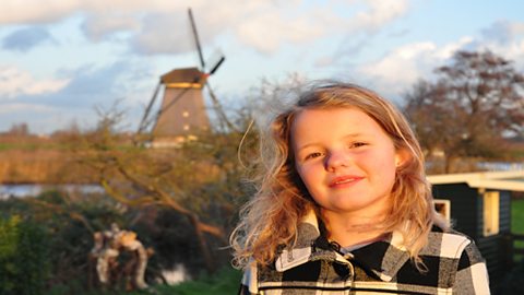
A location in Europe - Kinderdijk, Netherlands. video
Nine-year-old Donna introduces Kinderdijk - a region famous for its canals and windmills.
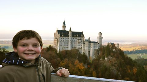
A location in Europe - Füssen, Germany. video
12-year-old Philipp introduces Füssen in the Allgäu region of Bavaria.
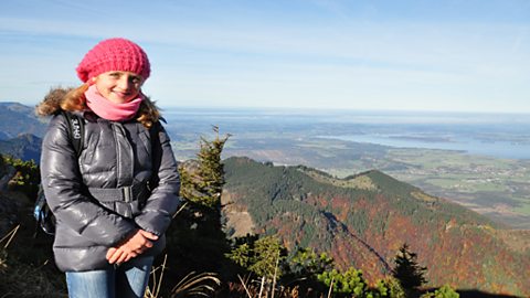
A location in Europe - Inzell, Germany. video
11-year-old Josephine introduces the physical and human geography of Inzell, in Bavaria.
A location in Europe - Hamburg, Germany. video
Nine-year-old Zoe introduces the physical and human geography of Hamburg, Germany.
A location in Europe - Cologne, Germany. video
Nine-year-old Niklas shows what life is like in the city of Cologne.