Summary

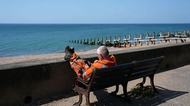
  1. More than 2,400 schools closed or disrupted in England and Walespublished at 14:57 BST

    Hazel Shearing
    Education correspondent

    At least 1,600 schools in England have experienced closures and disruption during this week’s heatwave. That’s on top of 840 in Wales.

    The Department for Education doesn’t publish a list of schools that have closed during the heatwave, so the figure for England is only an estimate.

    We’ve been looking at individual councils’ websites in areas most affected by the heatwave, and counted 1,691 that have fully or partially closed, or that have offered parents the option to pick their children up early.

    The actual number is likely to be higher, not least because councils aren’t required to publish this data and some schools might not appear on their lists.

    Most schools have stayed open, although academy trusts have reported lower attendance over the heatwave.

    Earlier, Prime Minister Keir Starmer said "each school will gauge for themselves the measures that are appropriate".

  2. The latest temperaturespublished at 14:55 BST

    A worker takes a break from working in the heat sat on a bench with feet up, near a beach and the sea.Image source, Getty Images

    We've just reported that the Met Office recorded a provisional temperature of 36.4C in Yeovilton - making it the hottest June day on record.

    Here are the latest provisional temperatures across other parts of the UK, as of 14:00 BST:

    • Otterbourne, Hampshire - 35C
    • Wiggonholt, West Sussex - 34.3C
    • Bournemouth Airport - 34C
    • Boscombe Down, Wiltshire - 34C
    • Bute Park, Cardiff - 33.3C
  3. Hottest June day record broken againpublished at 14:36 BST
    Breaking

    The Met Office has recorded a provisional temperature of 36.4C at Yeovilton, Somerset, making it the hottest June day on record.

    This beats yesterday's hottest June temperature record of 36.1C in Hampshire, which broke the longstanding record from 1976.

    A dog in Pilton, Somerset, earlier todayImage source, Philbert Nut / BBC Weather Watchers
    Image caption,

    A dog in Pilton, Somerset, earlier today

  4. It's very hot - here are four reasons whypublished at 14:31 BST

    Helen Willetts
    BBC Weather

    A 'heat dome' has developed

    At the centre of this is a large, slow‑moving area of high pressure that has effectively produced a "heat dome".

    The high pressure causes air to sink, and as it sinks it compresses and warms.

    At the same time, it suppresses cloud formation, allowing long hours of strong sunshine. Because the system is slow to move, heat builds up day after day and becomes trapped beneath this “lid” of stable air.

    Strong summer sunshine

    At this time of year, we have what’s called a "positive energy balance" - meaning more energy is coming in from the sun than is escaping back into space at night.

    Under clear skies, that energy builds quickly, driving temperatures higher by day and with short nights, less energy is lost at night.

    Hot air being drawn in from the south

    The position of this high pressure is also key. It’s pulling up very warm air from southern Europe and beyond.

    So we’re not just heating the air locally — we’re importing already hot air, where temperatures are also widely extreme and red warnings have been and are still in force. On Tuesday, France broke its all time temperature record, reaching 44.3C.

    Dry ground intensifying the heat

    Although there has been some recent rain, the ground has dried out rapidly.

    That means less of the sun’s energy is being used to evaporate moisture, and more goes directly into heating the surface and the air above it — further boosting temperatures.

    In short, the reason it's so hot is acombination of a persistent high pressure evolving into a heat‑trapping dome, strong sunshine, imported heat, and dry ground that’s driving this exceptional spell.

    Infographic titled “How a heat dome forms,” explaining the process in three labelled steps. A large dome shape sits over a landscape, representing trapped hot air. Step 1: “A mass of warm air builds up in still and dry summer conditions.” Step 2: “High pressure in the atmosphere pushes the warm air down,” shown by downward arrows above the dome. Step 3: “The air is compressed and gets even hotter,” illustrated with wavy heat lines beneath the dome. Curved arrows along the sides show air circulating within the dome, and ground features such as hills or mountains appear underneath. Source is the US National Oceanic and Atmospheric Administration (NOAA), with a BBC logo at the bottom.
  5. How are official temperatures measured?published at 14:28 BST

    Helen Willetts
    BBC Weather

    A purple banner which says 'your voice'

    Jamesgot in touch from "sweltering" Barwell in Leicestershire. He wants to know how the Met Office and BBC measure temperature.

    All official UK air temperatures are measured in a standardised way which allows readings to be comparable across the country and over time.

    Across the UK there is a network of Met Office weather stations where the air temperature along with other observations are recorded.

    These thermometers live within a Stevenson screen to avoid direct heat. These boxes are painted white to reflect direct sun and louvred to ventilate.

    In order to take a true air temperature, not a ground one, the screens sit 1.25m above the ground.

    There are also strict rules about location, for example, not on concrete and away from buildings.

    So when we say it’s 35C, that’s the standardised temperature not a reading influenced by direct sunshine or a hot surface.

    A stevenson screenImage source, Getty Images
    Image caption,

    An example of a Stevenson screen

  6. Is El Niño playing a role?published at 14:24 BST

    Mark Poynting
    Climate reporter

    Purple banner which says Your Voice

    Rob, 28, says many people will blame this extreme weather on the El Niño weather pattern. Can you explain how climate change may be contributing to the extreme heat as well?

    It’s a good question, but scientists aren’t blaming this heat on El Niño.

    Let’s recap: El Niño is a natural weather phenomenon which develops when a change in wind patterns allows warmer waters to spread across the tropical Pacific Ocean. It happens every two to seven years, roughly.

    Earlier this month, scientists declared that a new phase of El Niño had begun.

    El Niño typically boosts global temperatures and can fuel heatwaves in South America, South East Asia and parts of Australia.

    But there is no clear or consistent link between past El Niño events and summer heatwaves in the UK.

    Instead, scientists are putting this week’s heat down to a combination of a strong high-pressure system and climate change.

    Line graph showing monthly global temperatures since 1975 compared with pre-industrial levels of the late 19th Century. Temperatures show a long-term rising trend - the result of climate change. But temperatures tend to spike in El Niño periods, shown in red, and fall in La Niña periods, shown in blue.
  7. Why climate change means more heatwavespublished at 14:22 BST

    Justin Rowlatt
    Climate editor

    We have always had hot days and heatwaves. Climate change doesn’t create every hot spell from scratch. But it does change the odds.

    Think about it. We don’t get that many days that are very hot or very cold. Most days are closer to average. Plot them on a graph and they look a bit like a bell, with the very hot and very cold days at either end.

    Global temperature has increased by around 1.4C since pre-industrial times. That may not sound much. But now look at the second curve. The hot end has shifted quite a bit.

    That means temperatures that used to be rare are now closer to normal - more days cross the line into extreme heat.

    So heatwaves become more likely. And when they happen, they are more likely to be hotter and last longer, because they are happening in a world that is already warmer.

    Infographic titled “A small shift makes a big difference,” showing how a small rise in average temperature increases the likelihood of extreme heat. A probability curve compares a dashed line for the “Previous climate” with a solid red curve for the “New climate,” shifted to the right. The horizontal axis runs from “Cold” to “Average” to “Hot,” while the vertical axis is labelled “Probability.” On the left, a blue shaded area illustrates “Less cold weather.” On the right, a larger red shaded area shows “More hot weather,” with a darker section highlighting “Extreme hot weather.” Source: US EPA.
  8. Why does the UK always seem to struggle in the heat?published at 14:14 BST

    Mark Poynting
    Climate reporter

    Purple banner which says Your Voice

    Gill wants to know: why does everything come to a grinding halt in this country when we get extreme heat or cold?

    I’m sure this is a question that many people will have been thinking, Gill.

    Fundamentally, the UK’s roads, railways, schools and hospitals are not designed for such hot temperatures.

    "The UK was built for a climate that no longer exists today and will be increasingly distant in years to come," the government’s climate adviser warned last month.

    There are no easy fixes but adapting to hotter summers will probably include a mixture of behavioural changes and infrastructure upgrades.

    In some European countries, for example, working conditions and school days are changed when red heat alerts are issued to protect people’s health.

    And many of our homes are likely to need cooling technologies such as air conditioning or extra shading through blinds or shutters.

    Much of this will cost money at a time when the government has repeatedly said that public finances are tight.

    But climate advisers argue that greater investment today would ultimately save money in the long run.

    A person uses a fan to cool down on a TfL bus service in east London on 24 JuneImage source, EPA
    Image caption,

    On this east London bus, the handhelds fans are helping passengers cool down

  9. Is climate change behind the heatwave? Will next year be hotter? Send us your questionspublished at 14:08 BST

    Purple banner with "Your voice" written on it in white

    Why is it so hot? Is climate change behind it? Is El Niño having an impact? Will next year be even hotter?

    You can send your questions to our Climate and Science team in the following ways:

    Please read our terms & conditions and privacy policy

    In some cases a selection of your comments and questions will be published, displaying your name and location as you provide it unless you state otherwise. Your contact details will never be published.

  10. Experts answer your heatwave and climate questions, as temperatures climb in UKpublished at 14:06 BST

    A woman sits on a bus holding a fan and a large bottle of waterImage source, Getty Images

    It's still hot. Very hot.

    Parts of England and Wales are enduring a second day under a rare red warning for heat - with an amber warning in place for other areas.

    Last night, the UK endured its warmest June night on record, as provisional temperatures in Cardiff did not fall below 23.5C. This followed the hottest June temperatures ever recorded on Wednesday after the mercury hit 36.1C in Hampshire.

    But that record could be broken again today, with temperatures already soaring above 34C.

    We've been sharing updates on the ongoing impacts of the heat and tips for keeping cool, as we have done across this week.

    We're changing things up for the next couple of hours, though, with a live Q&A on the effects of climate change, and how it could make heatwaves more frequent and intense in the future.

    And we want to hear from you.

    We'll have correspondents and reporters from the BBC's Climate and Science unit - as well as from our Weather, Health, Money & Work and Learning & Identity teams - on hand to answer your questions.

  11. Temperatures top 34C as six NHS trusts declare critical incidents - the latestpublished at 14:03 BST

    Craig Hoyle
    Live reporter

    A woman in a crowd fans herself, she is surrounded by people wearing sunhats.Image source, Getty Images

    The weather

    A heatwave continues to grip the UK. In some parts of the country temperatures have provisionally topped 34C.

    Red weather warnings have been extended until 21:00 on Friday - this is the first time we have ever seen the warnings in place for three successive days, our lead weather presenter writes.

    As of 13:00 BST, the hottest temperature recorded was 34.7C at Shoreham Airport and the heat is expected to be at its highest at around 15:00 or 16:00, so it could climb further.

    Yellow thunderstorm warnings have also been issued for Northern Scotland, Northern Ireland and south-west England.

    The impact

    Staying cool

    As temperatures remain high today, we have top tips on how to travel, how to sleep and how to stay safe when swimming outdoors.

    And, we've been hearing from you. Davina in County Down has been sharing her tips for keeping her dog Chico cool, while gritters are out in force in Scotland to stop surfaces melting.

    We'll shortly be running a Climate Q&A with with correspondents and experts from BBC teams - here's how you can get involved.

  12. The first time we've seen three successive days of red weather warningspublished at 13:52 BST

    Elizabeth Rizzini
    Lead weather presenter

    A map showing the UK with red and orange markings and temperatures ranging from 15 in Lerwick to 36C in Cardiff.
    Image caption,

    The current red weather warning expires on midnight tonight. Temperatures could reach 36C in parts of the UK

    This is the first time we have ever seen a Met Office red weather warning for extreme heat issued for three consecutive days.

    Red warnings are extremely rare and warn of a danger to life.

    The red warning issued for yesterday and today was only the second ever issued for extreme heat.

    The first was issued in July 2022 when temperatures on 19 July that year broke the UK national record with 40.3C at Coningsby in Lincolnshire.

    The current warning which covers central and western areas of England and Wales including as far north as Birmingham and as far south as Portsmouth expires at midnight tonight.

    A new warning then takes over, encompassing an area further east including Kent to reflect where the highest temperatures and humidity levels will be on Friday. This warning is in place from midnight until 9pm on Friday.

    Some areas such as London, Oxford and parts of Sussex will stay in the warning area for 3 days. It will impact millions of people. Within the new red warning area temperatures could reach 36 or 37C accompanied by very high humidity.

    Further west, while still very hot with an amber warning for extreme heat in place, it will feel a little cooler than the peak heat of Wednesday and Thursday.

    The east and south-east of England will retain the heat for longest with temperatures still peaking in the low 30s into Saturday.

    By Sunday it should feel much more comfortable across the whole of the UK with westerly winds bringing a relief from the hot condtions.

    Extreme heat in London on Friday
    Image caption,

    A new warning is in force from midnight tonight, until 21:00 on Friday

  13. Six NHS trusts in England declare critical incidents, sources tell BBCpublished at 13:45 BST
    Breaking

    Nick Triggle
    Health correspondent

    At least six NHS trusts in England have declared critical incidents because of the heatwave, sources have told the BBC.

    NHS England was alerted to six critical incidents on Thursday morning.

    It comes amid reports the extreme heat has caused problems with IT systems, cancer equipment, lab testing and scanners.

    Critical incidents are declared when a service is under extreme pressure that threatens a hospitals ability to deliver safe and effective care.

    NHS trusts use it as a signal to the workforce and wider system that staff may need to be redeployed and patients sent to nearby hospitals.

    Two the BBC has been reporting already are Portsmouth’s Queen Alexandra Hospital which declared a critical incident after a cooling system supporting "critical infrastructure" failed partly due to the pressures of the heatwave.

    The Norfolk and Norwich NHS Trust has reported one too saying its cooling systems used to keep it scanners running had been affected by heat and humidity.

    To put that in context, the NHS has got to the point in recent winters where more than 20 NHS trusts have declared critical incidents at points.

  14. Temperatures top 34C in some parts of UKpublished at 13:42 BST

    The latest provisional temperatures are in. As of 13:00 BST, parts of the UK have surpassed 34C.

    Here's a closer look:

    • Shoreham Airport - 34.7C
    • Thorney Island, West Sussex - 34.5C
    • Yeovilton, Somerset - 34.5C
    • Larkhill, Wiltshire - 33.9C

    Meanwhile, the temperature at Jersey Airport is continuing to rise, it has now reached 36C.

  15. It's Chico time (to cool down) for this pooch in County Downpublished at 13:28 BST

    Barra Best
    BBC News NI weather presenter

    A woman and a small dog with white fur. The dog is sitting on the woman's knee. She's sitting on a bench. She has short hair and is wearing a blue and white pattered top. Bushes are in the background.
    Image caption,

    Davina Girvan and her dog Chico at Seapark in Cultra

    Davina Girvan is making sure her dog Chico stays cool in Cultra, County Down.

    "We bring him down early in the morning with plenty of water, let him have his walk around," she says.

    The Lhasa Apso is named after singer and former X-Factor contestant, Yousseph "Chico" Slimani.

    Davina says "he goes in the wee stream to cool off and then we go back in the car which has a cool mat with gel along the back seat so that when he moves it activates the gel to keep him cool".

    "Once he's panting or looking for shade that's when we leave," she adds.

    Chico Slimani in a white t-shirt.Image source, Getty Images
    Image caption,

    Chico Slimani competed on the X Factor in 2005 and is the namesake for Davina's dog - he's pictured here in 2010

  16. Germany bracing for possibly recording-breaking weekend of heatpublished at 13:11 BST

    Bethany Bell
    Reporting from Leipzig, Germany

    People on a boat sat under blue umbrellas, as people walk in the background.Image source, Getty Images
    Image caption,

    People are finding shade under parasols during a boat tour on the Spree river in Berlin

    Meteorologist Oliver Reuter says the heatwave in Germany will "ultimately be be described as historic".

    Speaking to German Press Agency DPA, he says this is not only because the previous German record for June "is likely to be significantly surpassed, but also because there have never before been peak temperatures of over 40C, or even 41C, across so many places on three consecutive days in Germany".

    What's the impact been?

    In Hamburg, a half marathon race due to take place on Sunday has been cancelled because of the heatwave.

    The heat is also affecting animals. One zoo in the west of the country took its alpacas to a nearby lake for a swim to cool off.

    Meanwhile in neighbouring Austria, temperatures could reach up to 40C in Vienna at the weekend.

  17. Temperatures climb to 33C in parts of UKpublished at 12:56 BST

    A person walks in the sun past beach huts.Image source, Getty Images

    We can now bring you a snapshot of the latest provisional temperatures - taken at 12:00 BST.

    The village of Yeovilton in Somerset reached 33.2C, while Jersey Airport recorded 34C.

    Other places have also hit temperatures above 30C:

    • Shoreham Airport - 33C
    • Thorney Island, West Sussex - 33C
    • Bournemouth Airport - 32.5C
    • Wiggonholt, West Sussex - 32.7C

    As a reminder, today's highest temperatures are likely to be recorded at around 15:00 or 16:00.

  18. 'If you see the gritters, it's not the council being daft'published at 12:45 BST

    Calum Watson
    BBC Scotland

    A man in orange overalls is pictured standing beside a yellow grit-spreading truck.

    As Scotland prepares for what could be its hottest day of the year so far, one council is sending out its fleet of gritters to treat the roads.

    Scottish Borders Council says that instead of salt, the lorries will be spreading a fine layer of sand to stop the road surface melting.

    The authority's chief executive David Robertson said some parts of the region could see temperatures reach 31C.

    "What we’re seeing is ambient road temperatures at the height of the heat up in the 40s - and that causes the tar on the road to melt.

    "So if you see the gritters, it’s not the council being daft – it's us trying to protect the road surface."

  19. South East Water acknowledges customer 'frustration' over hosepipe banpublished at 12:27 BST

    A man with short aubern hair and a beard wears a grey shirt and orange high vis jacket while standing in a water treatment plant
    Image caption,

    Nick Price says resilience works and repairs are in progress to ensure that hosepipe bans become "a much less frequent occurrence"

    South East Water says it acknowledges customers will be frustrated by a hosepipe ban that's been introduced in Kent.

    Around 850,000 customers will be affected by the ban, which has been put in place "due to high temperatures and record demand for water".

    The company's treatment works are all operating at 100% but are struggling to keep up with "demand at record levels", head of water resources Nick Price tells the BBC.

    "Reservoir levels are healthy," he says, meaning there's no underlying shortage of water - just a shortage of processing capacity.

    To give a sense of demand, Price explains the typical daily water usage in June is 580 megalitres, but "yesterday it was over 680 megalitres".

    Price says he understands frustration over the ban when South East Water is still losing 100 million litres of water a day through leaks.

  20. Yellow thunderstorm warning issued for Northern Irelandpublished at 12:09 BST
    Breaking

    The Met Office has just issued a new yellow thunderstorm warning for Northern Ireland. It will come into effect from midnight on Friday, lasting until 10:00 BST.

    There are already several weather warnings in place across parts of England, Scotland and Wales over the coming days - you can read more about those in our previous post.

    A map showing the area of northern Ireland highlighted in yellow with an icon indicating a yellow warning for thunderstorms